A weakened polar vortex: the root cause
Source: https://www.sciencealert.com/here-s-how-the-freezing-polar-vortex-is-fueled-by-global-warming.
The loss of sea ice is the root cause of the changes underlying the Arctic Oscillation Index and the North Atlantic Oscillation Index, illustrated below. These changes have significantly decreased the temperature difference between the Northern Hemisphere’s mid-latitudes and the North Pole, increasing the likelihood of severe winter outbreaks, such as those which occurred in the eastern US and northern Europe in 2010 (including the “Snowmageddon” blizzard which shut down the Federal Government in Washington in February that year), 2011 and 2012 and in Eastern Europe in January 2012. Whilst it is difficult to predict weather patterns from year to year, with the continuing loss of sea ice it is feared that similar weather conditions may tend to become the norm rather than the exception.
The loss of sea ice is the root cause of the changes underlying the Arctic Oscillation Index and the North Atlantic Oscillation Index, illustrated below. These changes have significantly decreased the temperature difference between the Northern Hemisphere’s mid-latitudes and the North Pole, increasing the likelihood of severe winter outbreaks, such as those which occurred in the eastern US and northern Europe in 2010 (including the “Snowmageddon” blizzard which shut down the Federal Government in Washington in February that year), 2011 and 2012 and in Eastern Europe in January 2012. Whilst it is difficult to predict weather patterns from year to year, with the continuing loss of sea ice it is feared that similar weather conditions may tend to become the norm rather than the exception.

Source: Charles H Greene, “The winters of our discontent”, Scientific American, December 2012, 37 at 40
Another consequence of the loss of arctic sea ice: its impact on the jet stream.
And more complex changes are afoot. The Arctic Oscillation Index is caused by week-to-week fluctuations in sea-level pressure between the Arctic and the mid-latitudes. If this pressure difference is small, the jet stream tends to weaken, allowing large-amplitude loops to form. In winter, a small pressure difference typically allows cold air to spill far to the south over the eastern US, western Europe and East Asia. The reduced temperature difference means that less energy is transferred between two of the large atmospheric circulation cells and the jet stream winds slow down, allowing Northern Hemisphere weather patterns to get stuck more often, bringing more extreme warm and cold spells[1].
From November 2013 through January 2014, the jet stream took on a remarkably extreme and persistent shape over North America and Europe. This global river of eastward-flowing winds high in the atmosphere dipped farther south than usual across the eastern U.S., allowing the notorious polar vortex of frigid air swirling over the Arctic to plunge southward, putting the eastern two thirds of the country into a deep freeze. Ice cover on the Great Lakes reached its second-greatest extent on record, and two crippling snow-and-ice storms shut down Atlanta for multiple days.
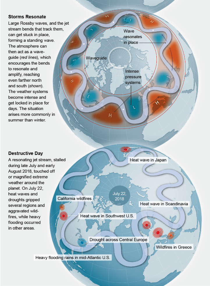
When the jet stream gets stuck during extreme events, the bends tend exceptionally far north and south. They fail to move eastward, and the larger the bends, the more punishing the weather gets near the northern peak and southern trough[2].
Michael E Mann, a professor of atmospheric science and director of the Earth System Science Centre at Pennsylvania State University elaborates: “A high-pressure system tucked inside the northern bend, or ridge, rotates clockwise and in summer brings dry, hot weather. A low-pressure system tucked inside the southern bend, or trough, rotates counter clockwise, leading to wet, cool weather. If the jet stream is weak enough, the S-shaped Rossby wave it is tracking (a wave created naturally as the earth rotates through a fluid, in this case air) can stall in place, without proceeding eastward—a “standing wave” pattern. The high and low weather systems spin in place, persistently baking the earth below or barraging it with relentless rainstorms and flooding”[3]. Under certain conditions the atmosphere can also act as a kind of waveguide or barrier, locking in the curved jet stream and the strong high- and low-pressure systems.
Furthermore, when waves are stuck in place as standing waves, under certain circumstances the bends can grow readily in amplitude, a phenomenon known as quasi-resonant amplification (QRA). Climate change can impact the shape of the jet stream and thus the amplifications and the frequency of extreme summer weather events. Climate simulations (CMIP5) show that the increased trend in conditions favouring QRA of recent times is driven by increases in greenhouse gas concentrations over time. Natural factors such as fluctuations in solar output and volcanic eruptions, as well as other human factors such as atmospheric sulphur dioxide pollution in particular, have also played a role.
Temperature data recorded at weather stations and the models also show that climate change is causing the Arctic to warm faster than the rest of the Northern Hemisphere, a situation known as Arctic amplification. A smaller difference in temperature between mid-latitudes and polar latitudes creates a slower jet stream overall, which favours more persistent weather patterns and is associated with the double-peak jet and QRA.
The consequence
This mounting trend helps to explain the spate of long-lasting, extreme summer weather events seen around the Northern Hemisphere over the past two decades. Scientists have recently shown that QRA conditions are linked to:
- the 2003 European heat wave,
- the 2010 wildfires in Russia and associated Pakistan floods,
- the drought that gripped Oklahoma and other parts of the U.S. in 2011, as well as wildfires in California in 2015, and
- the 2016 Alberta wildfires and now the unprecedented California wildfires of 2018.
Human-caused climate change has increased the likelihood of these excessive weather events by roughly 50 percent over the past few decades.
The IPCC and the CMIP5 experiments assess future conditions under different scenarios, everything from deep, immediate cuts in carbon dioxide emissions to a world that just keeps emitting more and more CO2 along the trajectory it has been taking. Somewhat surprisingly, under that so-called business-as-usual scenario, it was found that the level of rising severity, the trend toward conditions favouring amplification, may flatten out until around 2050. But don’t be fooled. It will then accelerate in the second half of this century.
Source: Michael E Mann, “The weather amplifier – Strange waves in the jet stream foretell a future full of heat waves and floods”, Scientific American, March 2019, 37 at 41 (extract from graphic). Graphic source: 5w Infographics
The reasons whereby and wherefore
The reason for this tendency to flatten out and then accelerate involves atmospheric pollutants such as sulphur dioxide, which are produced by coal burning and other industrial activities. These pollutants form particulates known as aerosols that drift in the atmosphere and reflect sunlight back to space, cooling the earth below. Taking precautions against this by installing “scrubbers” in smokestacks to remove the sulphur dioxide from the emissions helped to save forests, lakes and streams, but it also left fewer aerosols in the atmosphere to reflect sunlight and counteract warming from rising CO2, one reason global warming has accelerated since the 1970s.
This will result in a dramatic reduction in aerosols between now and mid-century—and much more warming. The effect is especially large in the mid-latitudes during summer, when there is maximal sunlight; much of it will no longer be reflected. In some model simulations, the resulting mid-latitude summer warming is so great that it exceeds the Arctic warming. Arctic amplification lessens or even stops. That would mean no increase or even a decrease in QRA (quasi-resonant amplification, above)—and no further worsening of the jet stream pattern behind the rise in extreme summer weather.
However, this short-term mitigating effect comes at great long-term expense. By mid-century the aerosols are mostly gone, so from that point on, rising greenhouse gases continue to drive all temperatures up. Once again the rise becomes faster in the polar region. Arctic amplification resumes, and the QRA events—the stalled, intense, hot, dry and wet weather patterns—start increasing again. By the end of the century they rise by roughly 50 percent relative to now. The change will be most prominent in summer, in mid-latitudes, which is especially troubling because that is where most people live and because that is where and when large quantities of crops grow—many of which do not hold up well in high heat.
The solution? “If the world acts now to quickly and significantly lower carbon emissions, we can avoid a catastrophic two degrees Celsius (3.6 degrees F) warming of the planet, and we will most likely avert any additional increases in QRA events. The safest (and most cost-effective) path forward is to immediately curtail fossil-fuel burning and other human activities that elevate greenhouse gas concentrations”.
Other contributors
Michio Kaku has also said that the jet stream played a major role in California's 2014 drought: "A lot of the weather from the moisture-laden air, which should go to California, is being diverted into Canada, where it freezes and it falls on your backyard,” he said. “So, in some sense, there’s a link between what’s happening in California as the jet stream diverts the moisture-laden air over Canada and then it snows on the United States.” (This also explains why Niagara Falls froze in 2014 at the same time it was warm in Sochi Japan where the Winter Olympics were being conducted). It is no mere coincidence then that California has elected to go its own way in implementing climate change preventative measures following the Trump administration’s announced intention to withdrawal from the Paris treaty.
“It’s all connected. If you take a look at the jet stream, you see that England is flooding right now. Latin America is warm, while California has a drought. We’re talking about instabilities caused by the erratic nature of the jet stream,” he said. The bad news is that this tendency seems to be irreversible at a certain point, meaning that “the new norm may be a North Polar region that is melting, causing more instability in this bucket, causing more things to spill out, which means more extremes. Some winters could be very mild; other winters could be horrendous.”[4]
The amount of Arctic sea ice[5] in fact set a record low for the month of January 2016[6]. This coincided with an unusually warm across the Arctic Ocean due to a shift in the jet stream. According to NSIDC, the extent of the sea ice during January 2016 averaged 5.2 million square miles, 402,000 square miles below the average set from 1981 to 2010. This was also the lowest January extent on satellite record, falling 35,000 square miles below the previous low recorded in 2011. Of course, Arctic sea ice expands and shrinks over the course of the seasons every year, but its overall area has steadily shrunk for the past few decades due to global warming[7]. Indeed, large passenger vessels can now sail through the previously impassable North West passage.[8]
It is not universally agreed among scientists that the loss of sea ice is responsible for this[9]. Some query whether the relatively short period that the Arctic amplification has been strong – about 15 years – is enough to link the two phenomena (loss of sea ice leading the Arctic warming and the changing pattern of the jet stream as a result). Others say that the amount of heat energy that has been added to the Arctic through Arctic amplification is an order of magnitude less than the energy in natural El Nino/Southern Oscillation-driven changes to the jet stream. Yet others again query whether the amplitude of jet stream waves is increasing.
However, the fact remains that the Arctic is warming faster than any other place in the world, and as a consequence walrus and polar bear populations in the area’s Pacific and Atlantic Ocean regions are thinning along with the ice sheets that are critical for their survival. Scientists estimate that Pacific walrus populations have fallen by half as a result of declining sea ice and hunting. The Atlantic stock, reduced by 80 percent through unregulated hunting between 1900 and 1960, is unknown, but estimates put the population at 25,000.[10]
These trends are ongoing[11], though not without a few idiosyncratic variations. In December 2015, a stronger-than-average polar vortex centred almost directly over the North Pole helped to confine cold air to the high latitudes, and December 2015 ended up being the warmest - and wettest - December on record in the U.S. But in the following February, whilst the main circulation of the polar vortex in the stratosphere and upper reaches of the troposphere remained in place over northern Greenland, it elongated and stretched like a deformed wheel, with one of its "spokes" extending southward into eastern Canada.
Lower in the atmosphere at jet-stream level, a sharp southward plunge of the jet stream nosedived into the Great Lakes and Northeast during Valentine's Day weekend 2016, accompanied by deep, cold air. Such polar vortex weakening events – a break in that “wall” we spoke of earlier - are associated with Arctic outbreaks and winter storms that have increased in the era of rapid Arctic change, essentially since the 1990s.
[1] Jeff Masters, "The Jet Stream is Getting Weird - Extreme summers and winters of the past four years could become the norm"), Scientific American, December 2014, 52-59.
[2] What follows is an edited summary of the article by Michael E Mann, “The weather amplifier – Strange waves in the jet stream foretell a future full of heat waves and floods”, Scientific American, 37.
[3] Ibid at 39. Similar extreme events attributable to climate change by virtue of more heat in the world’s oceans, more heat and water vapour in the atmosphere and regional and other factors are described in an article by Jennifer Francis, a senior scientist at the Woods Hole Research Center in Falmouth, Mass: "Rough weather ahead", Scientific American, June 2019, 46-53. The extreme nature of those events is independently described in the Foreword.
[4] http://www.cbsnews.com/news/extreme-weather-polar-vortex-and-jet-stream-unstable-expert-says/
[5] The term “sea ice” describes frozen ocean water that melts in the summer and refreezes in the winter. Usually it is at its smallest in September and reaches its largest expansion in March.
[6] Report of the National Snow and Ice Data Centre (NSIDC): https://weather.com/news/climate/news/arctic-sea-ice-record-low-january-2016
[7] Report of the National Oceanic and Atmospheric Administration (NOAA, an American scientific agency within the United States Department of Commerce focused on the conditions of the oceans and the atmosphere).
[8] https://www.polarcruises.com/arctic/ships/expedition-ships/ocean-endeavour-arctic/northwest-passage-2018#rates_56
[9] Masters, op cit, 58-59.
[10] Darryl Fears, op cit.
[11] https://weather.com/science/weather-explainers/news/polar-vortex-cold-outbreak-feb2016
Next
