2019 Australia's hottest year
Header: Walwa fire Twitter: Declan Kuch
Have you read the preceding page Australia's position?
Background
Have you read the preceding page Australia's position?
Background
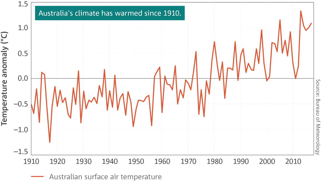
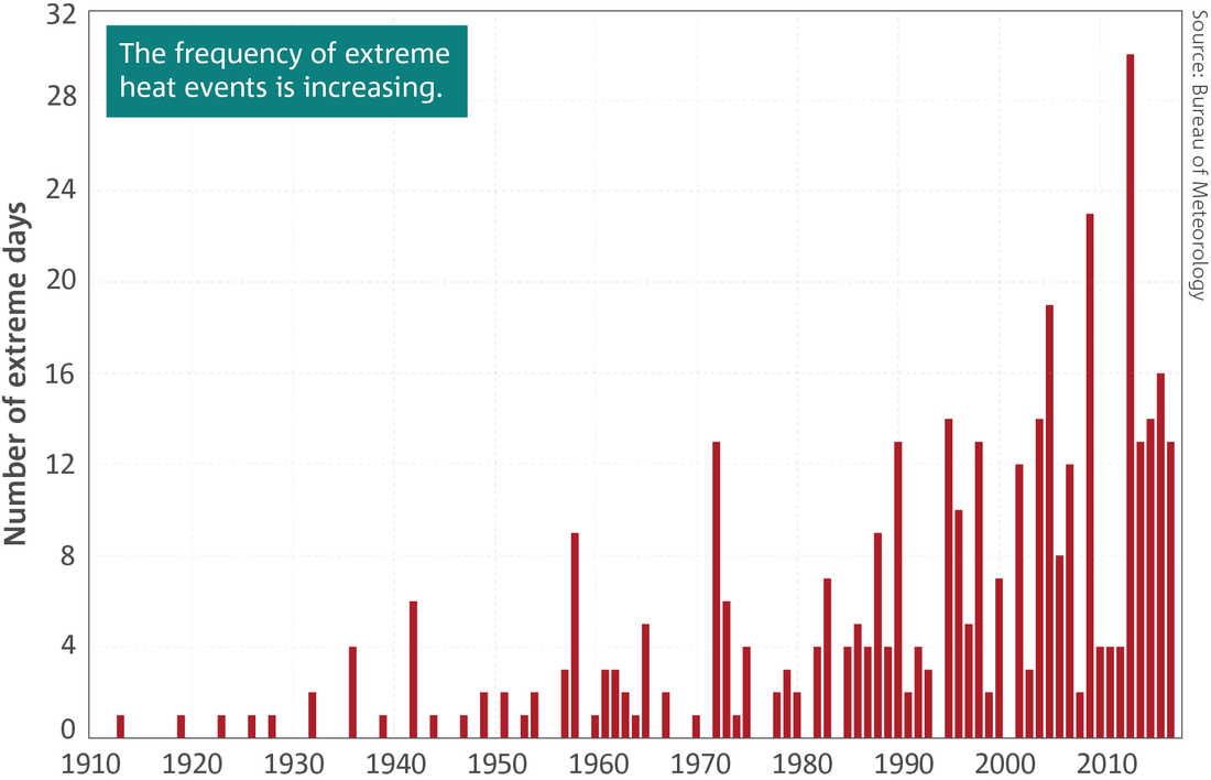
- Australia’s climate has warmed by just over 1 °C since 1910, leading to an increase in the frequency of extreme heat events.
- There has been a long-term increase in extreme fire weather and in the length of the fire season across large parts of Australia since the 1950s.
- April to October rainfall across south-eastern and south-western Australia has declined.
- Rainfall has increased across parts of northern Australia since the 1970s.
- There is evidence that some rainfall extremes are becoming more intense.
- There has been a decrease in the number of tropical cyclones observed in the Australian region since 1982.
- A downward trend in snow depth has been widely observed for Australian alpine regions since the late 1950s.
Source: BOM: State of the Climate: Australia’s changing climate
http://www.bom.gov.au/state-of-the-climate/australias-changing-climate.shtml
2018, described in the Foreword, may have been impressive in its record setting, but it was totally eclipsed by 2019 which would prove to be Australia's warmest year on record and the driest.[1] Although short-term climate drivers, particularly in the Indian Ocean, contributed to Australia's hot year, the background warming – caused by rising greenhouse gas emissions – is clear. Bushfire risks reached record high levels for Australia at the end of 2019, with December heat way above any previous readings for that month.
 BOM: State of the Climate: Australia’s changing climate
http://www.bom.gov.au/state-of-the-climate/australias-changing-climate.shtml BOM: State of the Climate: Australia’s changing climate
http://www.bom.gov.au/state-of-the-climate/australias-changing-climate.shtml
From heatwaves and fires to floods and snow, 2019 was a big year of weather. Annual rainfall was the lowest on record. Australia started 2019 with an extreme heatwave in January that helped make the 2018-19 summer the country's hottest. That
record could be eclipsed as soon as this (the 2019-20) summer after a
scorching December that brought an exceptionally warm end to the year.
On December 18 Australia had its hottest day, with an average maximum of
41.9 degrees. The month also included the next six warmest days, all
shading the previous 40.3-degree high set in early 2013. The week ending
Christmas Eve was Australia's hottest week, with an average of 40.5
degrees.
|
|
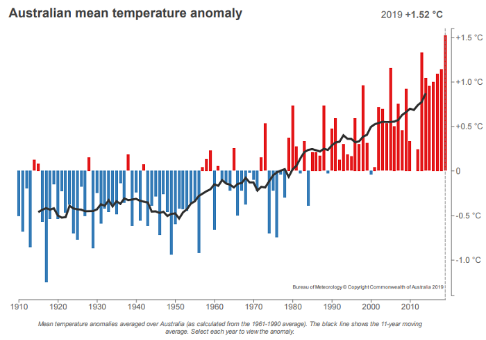
Anomalies are departures from the twentieth century average, as stated. Source: Bureau of Meterology
Maximum and mean temperatures for 2019 were easily the warmest in data going back to 1910. Daytime temperatures were 2.09 degrees above the 1961-90 average, beating the previous high set in 2013 by 0.54 degrees. Annual mean temperatures were 1.52 degrees above the norm.
The combination of extreme heat and low rainfall meant the bushfire season started early in many parts of Australia. The Forest Fire Danger Index – gauging temperature, humidity, wind speed and drought to assess the potential threat of the spread of fire – was the highest on record over most of Australia, including almost all of NSW. Fire seasons are getting longer – extending as much as a month in parts of south-eastern Australia.
The size of December's temperature leap was perhaps the standout statistic from 2019. At 38.6 degrees on average, December's daytime temperatures were a full 4.15 degrees above the 1961-90 benchmark, beating a record set only a year earlier, by 1.74 degrees.
